The Role of Smallholders
Smallholder livelihoods play an important role in evaluating land degradation
"Taken at the end of the dry season, the photograph shows fallow, rain-fed fields (brown and tan) — except around the margins, where forested villages have access to river water. The largest village in the scene is Sciovele.
Thin river channels run through long floodplains that arc around the fields. These floodplains are part of a wide, low-lying wetland system that supports both swamp vegetation and another set of fields where crops thrive through the dry season. Farmers in the lower wetlands take advantage of flood-recession agriculture, where wet-season rainwater drains more slowly and is available for plant growth even in the middle of the dry season.
The wetlands are part of the complex coastal zone of Lake Tana, which lies just outside the top of the image. Individual fields and angular margins at the floodplain are indicative of the human use and modification of the wetlands. The Gilgel Abbay River is lined with very narrow fields that give the greatest number of farmers access to the water.
Forests occupy parts of the wetlands; they also stand on a few patches of higher ground, such as the hill in the centre of the image and five small circular patches dispersed among the fields. Some of these forests surround monasteries that are characteristic of the region.
The relatively high rainfall in the Ethiopian Highlands makes the region suitable for growing coffee, oilseeds, and grains (especially subsistence crops such as wheat and sorghum). However, a recent years-long drought is threatening Ethiopia’s food supply."
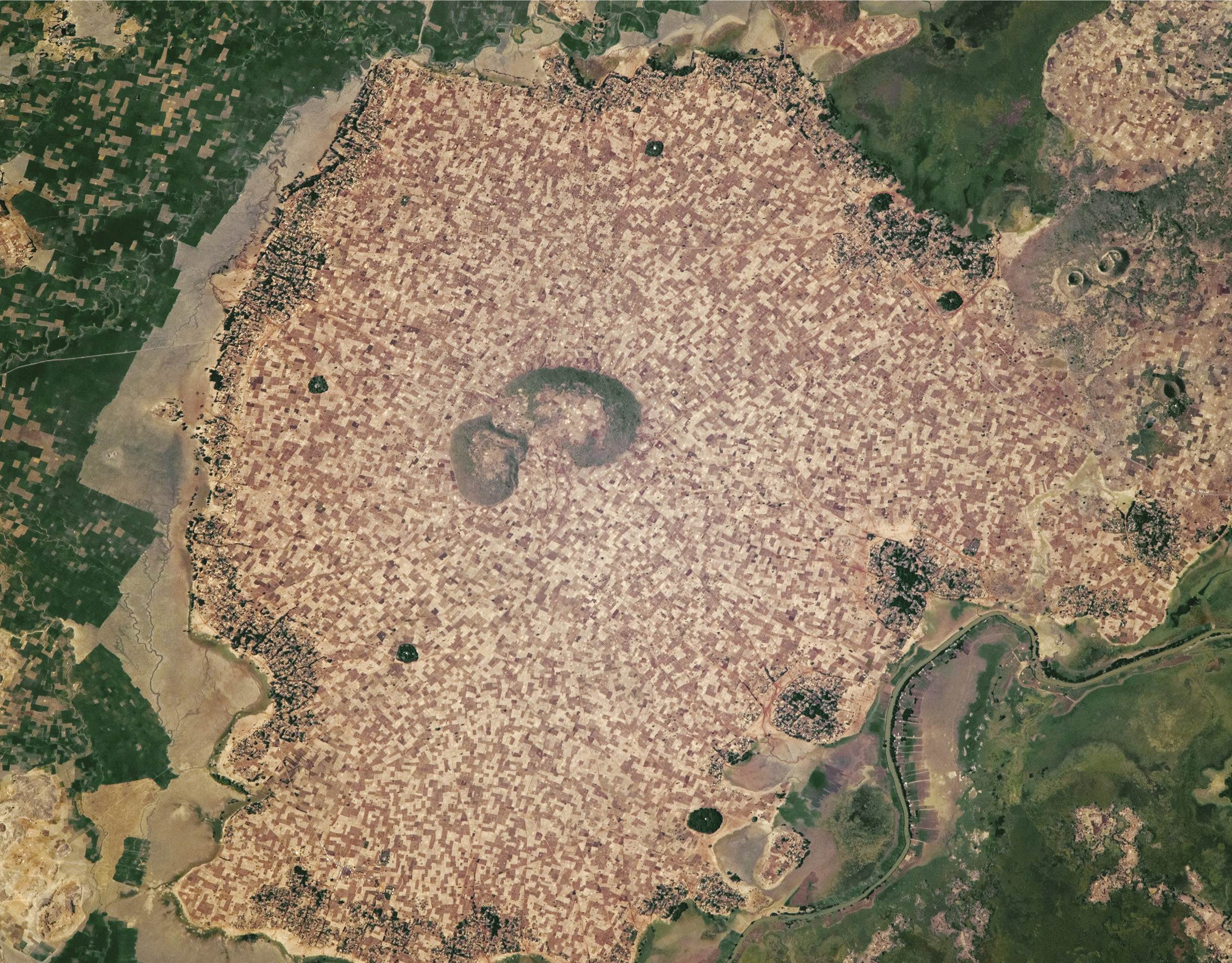
Smallholder fields and forests in the Ethiopian Highlands.
Source: Text by: NASA, https://visibleearth.nasa.gov/view.php?id=89948 Photo Credit: Astronaut photograph ISS050-E-30105, NASA Visible Earth.
1st Viewpoint: The 'desertification paradigm' - smallholders’ role in degradation.
The ‘desertification paradigm’ may be stated as follows: “The implicit basis of the desertification paradigm is the idea of an ecosystem at equilibrium in which a perturbation is followed by a natural readjustment back to a stable state. Thus vegetation always evolves, through natural succession, towards its ‘climatic climax’. However, human agency, through ‘misuse’ of the land, may dislodge the ecosystem irreversibly from its former equilibrium. Restoration is not economically possible within an acceptable time-frame. The common use of the term ‘fragile’ denotes the susceptibility of dryland ecosystems to such degradation”.
The paradigm has been embedded, over a century or more, in rapidly growing literature derived from technical and expert observations of over-cultivation, overgrazing, deforestation, desiccation and salinisation in dryland countries. The historical roots of this literary tradition are to be found in the hypothesis of an advancing Sahara, for which smallholders (both farmers and pastoralists) were held culpable. Since the 1950s, UN institutions, donors and national governments financed or facilitated these studies.
The ‘advancing Sahara’ hypothesis is still influential. The ‘Great Green Wall’ strategy born at a meeting of West African heads of state began with a reforestation goal for the governments along its southern edge, despite the failure of some earlier tree planting programmes and the uncertain performance of such schemes since. Making enormous demands on capacity and ignoring experience of ‘top-down’ imposition elsewhere, this crude prescription has now evolved into a more realistic landuse planning framework which depends for its success, not only on European Commission finance, but also on smallholders. Yet China has recently announced its intention to plant a forest wall against the Gobi Desert.
Under-investment is linked to small-scale agricultural operation. The priority given to food security at the level of the family farm naturally follows from low productivity and high environmental variability, while over-dependence on market production is risky. So is dependence on soil amelioration: he (or she) who spends family savings on chemical fertilisers will lose the most when drought strikes. Ruminants that perform better under extreme variability are preferred by livestock breeders. This clash occurs between the goals of survival and those of profit and affects all smallholders. Profits (if any) may be invested in animals, urban migration, real estate (property), or business, which may be less risky than reinvesting in farming (for example, in Senegal).
Within this framework, landscapes are presently undergoing a transition from ‘wildscapes’ (where human impact is less obvious) into agrarian, urbanised and industrialised landscapes – or anthromes, driven by demographic growth, technology change, social and economic transformation and other global forces. This transition is not painless, either for the life-supporting natural ecosystems or for the human systems that have increasingly dramatic impact nearly everywhere. These tensions, in combination with climatic aridity, variability and change, have brought dryland degradation to centre stage in global environmental management. Smallholders - whether farmers or pastoralists - operate under alarming scenarios of soil and water erosion, declining bio-productivity, episodic floods and droughts, soil salinisation and deforestation.
In expert diagnosis, ‘over use’ of land by smallholder farmers and pastoralists rapidly gained currency during the 20th Century2nd Viewpoint: A ‘resilience paradigm’ - smallholders’ role in sustainability.
The 'resilience paradigm’ begins with recognising that dryland ecosystems are not characteristically at equilibrium. As their productivity depends primarily on variable rainfall, they are better understood as being in a state of disequilibrium. For example, when pastures fail, animals die or migrate. But seed banks in the soil ensure that vegetation recovers, though not necessarily with the same species composition. In the Sahel, perennial grasses were replaced by annuals when the rain returned. This capacity of the ecosystem to maintain its functional integrity while adjusting to various drivers justifies describing it in ecological terms as unstable and resilient.
During the past three decades, Earth satellite data have provided a fresh perspective on dryland degradation that has generated growing literature on “regreening”. They offer a compatible basis for global estimates and a testing ground for theories of change. Results from West Africa produced surprising counter-evidence to the orthodox view of progressive degradation (see case study: Sahel).
Unexpectedly, increased NDVI values were found to be most visible in the semi-arid and arid ecological zones, where dense human and livestock densities had appeared to present the greatest threat. The trends were found to be significant throughout the period from 1982 (when the first data became available) to 2006 and significantly correlated with rainfall. However, there are localised exceptions, where rainfall is not the sole explanatory factor and management may have also had a role. Given the predominance of smallholders in the region’s agriculture and livestock sectors, such a conclusion seems reasonable. But much more research on the ground is needed. While positive trends in biomass production are indisputable, field studies of woody vegetation at local scale show contrary trends.
Some degraded landscapes show evidence of recuperation in their productive capacity through uptake of sustainable land management (SLM) practices, for example, via livestock grazing and redistribution of organic nutrients; reforestation or plantation of trees; protection of enclosed rangelands from grazing animals; intensive use of domestic waste on gardens; and long rotational fallows. There is an extensive inventory of SLM practices by smallholders which can support such a recovery of bioproductivity, if found economically viable. But within a complex and dynamic framework, the search for ‘solutions’ to dryland degradation is much broader than technology alone, important though it is.
Degradation is contextual and almost infinitely variable. So also is sustainability. This wider livelihood frame provides the necessary context for evaluating degradation and sustainability, in particular in relation to ameliorative action and policy, which needs to be as holistic as the dryland household itself

GDP per capita in 2015 (current US$).
Source: Worldbank, CC BY-4.0.

Spatial representation of people’s perceptions of changes in vegetation cover and NDVI trends (by 20 × 20 km grid cells) in Senegal.
Number of focus groups reporting observations of degradation of the vegetation cover.
Grey grid cells represent the area of Senegal that was not crossed by any of the mapped routes of transhumance and was hence excluded
from the analysis. There is an apparent contradiction between increasing NDVI values and environmental degradation perceived by local people.
However, in many instances, increasing vegetation cover was the result of an increase in undesirable plant species
Source:Herrmann, S., 2014

Spatial representation of people’s perceptions of changes in vegetation cover and NDVI trends (by 20 × 20 km grid cells) in Senegal.
Number of focus groups reporting observations of rehabilitation/improvement of the vegetation cover.
Source:Herrmann, S., 2014

Spatial representation of people’s perceptions of changes in vegetation cover and NDVI trends (by 20 × 20 km grid cells) in Senegal.
Observations of degradation and improvement combined.
Source:Herrmann, S., 2014

Spatial representation of people’s perceptions of changes in vegetation cover and NDVI trends (by 20 × 20 km grid cells) in Senegal.
NDVI trends for 1982–2008 at the original 8 × 8 km resolution.
Source:Herrmann, S., 2014

Spatial representation of people’s perceptions of changes in vegetation cover and NDVI trends (by 20 × 20 km grid cells) in Senegal.
Observations superimposed on NDVI trends averaged for 20 × 20 km grid cells.
Source:Herrmann, S., 2014
|
Cultivation
|
Croplands |
|---|---|
| Expanding Cultivation | |
| Increasing Production | |
| Closing Yield Gaps | |
| Fertilisers | |
| Irrigation |